Saturday, October 27, 2012

Maine Roadsides

Big Indian, US1, Freeport

US 1 Freeport Big Indian

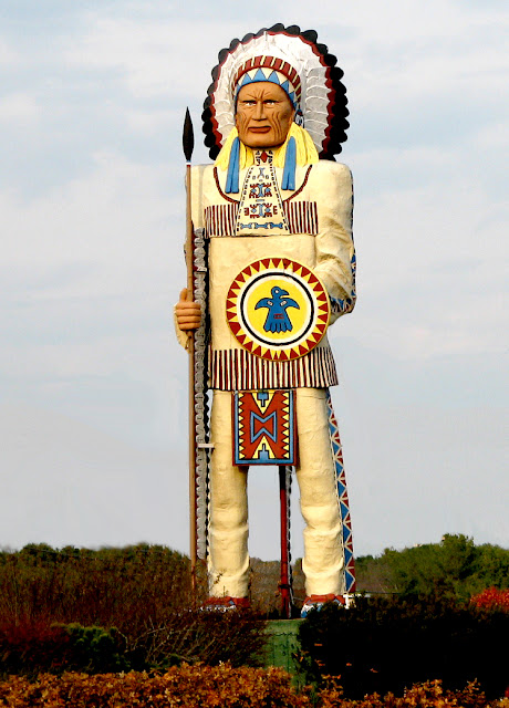
Bruce and I were driving along US 1 toward Freeport when we came across this Indian statue.  We snapped a picture of it at high speed, but didn't know what it was, since it didn't seem to be a sign for any of the businesses next to where it stands.  It is in front of the Conundrum Wine Bistro.  Just beyond it is a sign for Winter People Image Marketing. 
After searching on the internet I found that the current owners, Winter People Image Marketing specializes in corporate and retail clothing that coinsides with the "Maine Way of Life."  the statue is known as, The Big Indian or BFI by the locals.  We can only assume the "F" stands for Freeport.
The Indian was commissioned in 1969 by the owner of the Casco Bay Trading Company, Julian Leslie, which sold "Native American souvenirs and curios, largely made in Japan. The statue is a large male Indian scultped by Rodman Shutt, Julian Leslie, and Mike Leslie.  The Indian is also known as Chief Passamaquoddy for the tribe that used to reside in the Casco Bay area.  It was built for $5000 and is 40 ft tall and 15 ft wide.  It is painted epoxy resin and fiberglass over welded steel angle irons or steel rods, chicken wire and papier mache, secured with wood braces and guy wires added for support after a hurricane.  Its base is concrete.

When Julian Leslie retired, the buildings and statue were sold to the Badger or Badge-A-Minit Ltd. company, who then sold the building to Levinsky's clothing store.  Phil Levinsky had the sculpture restored.  The facelift included structural reinforcement and a repainting using weatherproof marine paints to bring back the Indian's bright colors.  The restorers even had to pull arrows out of the beleaguered Indian that had been shot by archers.

The Big Indian has seen it all: once standing in front of a Native American goods store, to clothing outlets, to a ski equipment company, and now an image-marketing firm, Winter People.
  
This Indian statue is included in the Art Inventories Catalog of the Smithsonian American Art Museum.  As impressive as this statue is, as you are driving along US 1, the Smithsonian reports that the statue has been the subject of some controversy.  Native Americans feel the statue is inappropriate and disrepectful of their heritage.  
In researching who Chief Passamaquoddy was, I find no reference to an actual person, but only to a tribe that are the original natives between Maine and New Brunswick.  There is a great website designed for kids that gives a quick overview of this tribe:  http://www.bigorrin.org/passamaquoddy_kids.htm.


Friday, October 26, 2012

Maine Lighthouses 5


Spring Point Ledge Light

Portland Harbor, Maine

This lighthouse marks the dangerous ledge on the west side of the main shipping channel from the south into Portland Harbor. Many vessels ran aground on the ledge before requests from seven steamship companies in 1891 convinced the federal government to build a lighthouse. The steamship companies had carried more than 500,000 passengers through the area during the previous year.  

Built on a cylindrical cast-iron caisson, the lighthouse is a typical "sparkplug" style of the period, but unlike many such structures, the tower is constructed of brick, rather than cast-iron.

The 54 foot lighthouse has a storeroom and cistern in the basement, topped by four levels, including a keeper's office, a watch room and two levels of living quarters.  A fifth-order Fresnel lens was installed and a fog bell hung on the side of the tower, which sounded a double blow every 12 seconds by means of a striking mechanism powered by a clockwork mechanism with 800 pounds of weights..  An oil room in the basement contained a 239-gallon tank for the kerosene that fueled the light in its early days.  It was electrified and automated in 1934.   In 1951 the 900 foot breakwater was constructed joining the lighthouse with the mainland. 

Spring Point Ledge Light was considered a "stag station," with a male keeper and assistant keeper living inside the tower.  Keepers had to be creative in their means of exercise. Somebody figured that it took 56 jogs around the tower's main deck to make one mile. It is told, once, a keeper was running laps in this fashion and forgot to close a trap door. He slipped through the opening and only a ladder prevented him from falling 17 feet to a rock ledge and swirling waves.

The lighthouse is easily accessible and the Spring Point Museum is located on the adjacent Southern Maine Technical College campus.  It is now owned by the Spring Point Ledge Lighthouse Trust.  Occasional open houses are held in the summer. 


Maine - Fort Gorges in Casco Bay

Fort Gorges from East Promenade Park, Portland, ME


Built on Hog Island Ledge, Fort Gorges was named after Sir Ferdinando Gorges, colonial proprietor of the Province of Maine. The fort's site allowed it to provide supplemental fire to both Fort Preble and Fort Scammel. Its location at the head of the harbor would also serve as a deterrent to vessels entering through the channels on either side of Peaks Island. Attackers coming around behind Great Diamond Island could be repelled by cannon on the top rear of the fort.

Work on Fort Gorges had began in 1858, and the pace of construction was increased with the outbreak of the Civil War. It was designed as a truncated octagon with a long sixth side at the rear, similar to Fort Sumter in Charleston, South Carolina. Granite walls were four feet thick.

The double-tiered arched gun galleries were to hold 28 cannon on each level. Rifle slits were provided along the rear wall, and the top tier was designed for 39 gun emplacements. The gun ports in the walls had iron shutters that opened and closed automatically in conjunction with the firing of the track-mounted cannon.

Construction was nearly complete by 1865, but no guns had been mounted at the end of the war. The ineffectiveness of cannon against steel-hulled ships, as evidenced in the battle between the Monitor and the Merrimack, helped render this fort obsolete.


Fort Gorges Photo on Marker Photo, Click for full size
By Unknown, undated


 Fort Gorges Photo on Marker
An 1871 order from the Army Corps of Engineers called for earthworks on top of the fort's granite walls. These sodded sand parapets were to provide protection for 14 huge Rodman guns to be mounted on the roof. The modifications were nearly complete when Congressional appropriations ended in 1876.  The top of the walls now appear to be planted with vegetation.

In this century, a storehouse was built on the parade ground. Submarine mines were kept here for use in World Wars I and II. 

 
The fort was last used by the military during World War II when it was used to store submarine mines. It was acquired by the city of Portland in 1960 and placed on the National Register of Historic Places. It is now open to the public as a park, and is accessible only by private boat. Visitors are recommended to carry a flashlight to enter the powder magazines.

Accessing the island involves crossing areas with strong tidal currents and should thus be attempted only under the right conditions, by people with sufficient experience, using a proper boat, i.e. don't try it with a canoe.

Maine Lighthouses 4


Portland Breakwater (Bug) Light
 
Bruce and I could see this lighthouse from the harbor at East Promenade Park in Portland.  We also saw the Spring Point Ledge Light and the abandoned Fort Gorges on Hog Island Ledge.  These will be covered in the next few blogs.

A 2,500 breakwater and lighthouse on the south side of the entrance to Portland Harbor was begun in 1836, but not completed until 1855.  In the early 1870"s the breakwater was extended approximately 200 feet and a new lighthouse was built at the end.  

Known locally as "Bug" light, the new lighthouse included Greek architectural elements.  The design of the cast iron tower is petite, with Corinthian columns created to resemble a 4th century, B.C. Greek monument.  A wooden keeper's house was built adjacent to the lighthouse in 1889.

In 1934 the light was electrified, the keeper's house removed and the light tended by the the keeper at Spring Point Ledge Light.  As shipyards expanded into the harbor to accommodate World War II shipbuilding, the breakwater was progressively shortened until the lighthouse stood only 100 feet from shore, making it obsolete.  The light was extinguished in 1942, declared surplus property soon after, and sold to the city of Portland.

In 1989, after standing unattended for a long time, repairs and restoration were completed and the light is now a favorite spot for visitors.

Wednesday, October 24, 2012

Maine Lighthouse 3


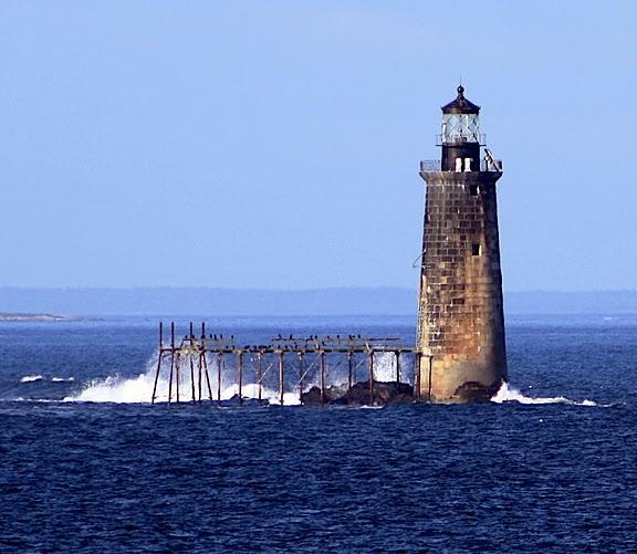
Ram Island Ledge Light

Ram Island Ledge Light
 

Bruce and I spied this lighthouse off the coast while we were traveling just North of the Portland Head Light.  Not knowing what it was, I had to do some research to identify it for you It is the Ram Island Ledge Light.

This light sits on jagged rocks at the north side of the entrance to Portland Harbor.  At high tide the ledges are completely covered and were the cause of many shipwrecks until a lighthouse was built there in 1905.  Ram Island Ledge protrudes 1,300 feet from Ram Island. The granite tower was built on a granite block foundation with an attached skeletal pier. It is 77 feet tall from its base to the middle of the round lantern and is listed on the National Register of Historic Places.

Gray, granite blocks were used to construct the tower and were cut from quarries on Vinahaven.  They give the lighthouse the appearance of being much older than it is. It can be seen from offshore at Fort Williams Park in Cape Elizabeth.

On Aug. 28, 1905, a fog bell was installed and in 1958 the lighthouse was converted to electricity. In 1959, the Coast Guard removed the three lighthouse keepers from Ram Island Ledge and the automated light and fog signal were tended remotely by keepers at Portland Head Light.  The light was converted to solar power in January 2001 and is still an active navigational aid. The lighthouse structure is not open to the public and is accessible only by boat.

Check out the photo below showing just why a lighthouse was needed at this location:

Ram Island Ledge Light
Photo Courtesy of:  U.S. Coast Guar

In July 2010, Ram Island Ledge Light was put up for sale to the general public.  The minimum bid was $10,000.  Dr Jeffrey Florman, a neurosurgeon from Windham placed the winning bid of $190,000 and it was sold on 9/14/2010.   Mainers were pleased the lighthouse remained in the hands of someone from Maine who wishes to restore and maintain the lighthouseIt can now continue to serve as an active navigational aid.

Sunday, October 21, 2012

More Road Signs

More Unique Road Signs
 
North Woods, New Hamphire
Photo by:  Cherri


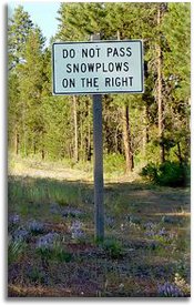
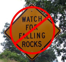
We found this sign in the North Woods of New Hampshire.  It makes you want to say, "Well, duh!"  I've also seen the same sign in Washington State.  

However, the real winner is the sign below near Mt Hood, Oregon where someone actually posted, "Duh" to the sign.  Love it


Near Mt Hood, Oregon

 US Highway 1

Below is the sign indicating this is where US Highway 1 begins in Fort Kent, Maine, at the Canadian border.  The road runs all along the eastern seaboard to Key West in Florida. 

Fort Kent, Maine
Photo by:  Cherri

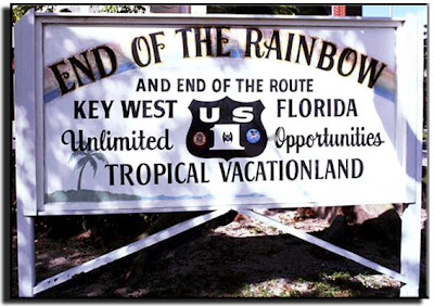
Below is the terminus of US 1 in Key West, Florida

Key West, Florida


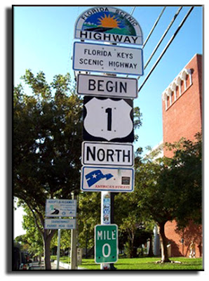
This is the actual Highway department sign in Key West, Florida.
Key West, Florida

Turkeys

 Here are turkeys crossing the road near the Umpqua River in Oregon.  We didn't visit here, but it was such a fun photo, I couldn't resist adding the road sign.


Sign in New Jersey

I found signs like this one on the internet and thought they were photoshopped.  However, in researching them, I found one man in Dennis Township, New Jersey actually has this sign posted on his property on Route 47.  His name is Richard Bradley, a 64-year-old retired circulation manager for the Philadelphia Inquirer and cabinetmaker. “I do it for the motorists to crack them up.”  An article about his signs appeared in the Press of Atlantic City.  Reportedly, he had another sign that read, "No White Pants After Labor Day."  Love his sense of humor. 

Dennis Township, New Jersey


Friday, October 19, 2012

Road Signs

North Woods Hampshire
Photo by:  Cherri

Bruce and I did see a moose crossing the road in the North Woods of Maine, but I was much too slow getting the camera out, so I recreated it in Photoshop. 


Maine
Photo by:  Cherri


It is reported that there are more 29,000 moose in the state of Maine.  That is more than any other state except Alaska.  Don't make it 28,999. 


NO!

 
Maine or New Hampshire
YES!

Funny thing is, both these signs were posted at various places in both Maine and New Hampshire.  Seems to me, one is better advice than the other.

More signs tomorrow!


Tuesday, October 16, 2012

Maine Lighthouses 2

Portland Head Light

Portland Head Light
Photo by:  Cherri Nowell


Portland Head Light in Southern Maine at Fort Williams Park in Cape Elizabeth marks the state's busiest harbor, boasting a combination of historic significance and beauty.  It is possibly the most visited, photographed and painted lighthouse in the United States.  The setting particularly inspired Henry Wadsworth Longfellow, who found the tranquil beauty well suited to writing poetry.  This is the lighthouse where he wrote his poem ‘The Lighthouse.’ 

Maine was part of the Massachusetts Bay Colony in the 18th century and Portland (known as Falmouth until 1786) had become one of the busiest ports in America by the late 1700's.  In 1784 John Hancock was governor of the Bay Colony and authorized construction of this first light house in Maine.  Construction didn't begin on Portland Headlight until 1787, before funds became available.  


At that time, while Maine was still part of the state of Massachusetts, George Washington engaged two masons from the town of Portland, Jonathan Bryant and John Nichols, and instructed them to take charge of the construction of the lighthouse on Portland Head. Washington reminded them that the early government was poor, and said that the materials used to build the lighthouse should be taken from the fields and shores, which could be handled nicely when hauled by oxen on a drag. The original plans called for the tower to be 58 feet tall. When the masons completed this task they climbed to the top of the tower and realized that it would not be visible beyond the headlands to the south, so it was raised to 72 feet.

The tower was built of rubblestone, and Washington gave the masons four years to build it. While it was under construction in 1789, the federal government was being formed and for a while it looked as though the lighthouse would not be finished. Following passage of their ninth law, the first congress made an appropriation and authorized the Secretary of the Treasury, Alexander Hamilton, to inform the mechanics that they could go on with the completion of the tower. On August 10, 1790, the second session of congress appropriated a sum not to exceed $1500, and under the direction of the President, “to cause the said lighthouse to be finished and completed accordingly.” The tower was completed during 1790 and first lit January 10, 1791.  The tower now stands at 101 feet above sea level and it's light can be seen 26 miles to seaward on a clear evening.  


President George Washington appointed its first keeper, Capt. Joseph Greenleaf. Since its construction, the tower has never been rebuilt. The light was originally fueled by whale-oil lamps and in 1855, a fourth-order lens was installed but replaced by a second-order lens in 1864. The light was automated in 1989.

The current keeper's quarters, which now serves as the museum, was built in 1791. Today, the U.S. Coast Guard maintains the light as an aid to navigation.


Monday, October 15, 2012

Maine Lighthouses 1

Cape Neddick Lighthouse
Photo by:  Cherri Nowell

Photo by:  Cherri Nowell

This is the Cape Neddick Lighthouse on the southern coast of Maine, north of Portland and South of Kennebunkport.  It is also known as the Nubble Light since it sits on a small rocky island off the coast named the Nubble.
The 41 ft. cast-iron tower was authorized by President Rutherford B. Hayes and first illuminated in July 1879.  The distinctive red oil house was added in 1902 and the walkway connecting the keeper's house and the tower added in 1911.  An 1891 fourth-order lens is still in use.  A bucket suspended on a line across the channel was used to transport supplies.  It is still used today for maintenance equipment.  The light itself was automated in 1987.

Upon researching the lighthouse I found there are miniature cast iron lighthouses on each of the posts surrounding the lantern room.  If I had known that when I was there I would have zoomed in on those posts.  If anyone has a photo of them, I would appreciate it if you would share it.  Thanks.

Another interesting fact is that there was a past feline resident of the lighthouse who weighed 19 lbs.  At one time he attracted as many visitors to the lighthouse as did the house itself.  He allegedly was the best mouser in Maine.  Supposedly, he regularly swam the channel to visit with mainland friends and then returned to the lighthouse to continue his post as resident mouser.  

As an owner of a 20 lb. cat, I can't imagine such an athletic endeavor.  I had to get a step stool for my cat so he could get up onto the dryer to eat her dry food.  She has to take a running start to make it to the bed.  I'm trying to put her on a diet.  Maybe if I get some mice she will get more exercise.

Cape Neddick Lighthouse is owned today by the town of York and managed by the Friends of Nubble Light.

Friday, October 5, 2012

Welcome

This is my new Blog Space for special places in the United States, Canada and Mexico.  A separate Blog is also posted for places in the state of Washington.  The URL to get to that page is:  http://travelswithcherrri.blogspot.com/  Note the extra R in Cherri.  It's a good thing I can't type, because otherwise the blog title would have been taken!

As you check out the blog you have reached you will see I have no idea what I'm doing.  This is a learn as you go experience.  My intention is to post photos and information about some of the places I have visited in hopes you will want to check these places out for yourselves.   I hope to add information, history and personal observations about them to peak your curiosity about them. 


Bruce and I are finally taking a vacation to New Hampshire and Maine this week to experience some New England Fall Color and explore some picturesque fishing villages along the coast.  I have a real interest in photographing some lighthouses and other points of interest in this region and will be sharing these as soon as I have time so sort through my materials. 

In addition to the current trip, I have scores of photographs and information from other trips throughout the United States, Mexico and Canada that I would like to share as time permits on this second blog.  Remember,  Travels with Cherri is for Washington State and Travel with the Locals is for the rest of the world (Ambitious, aren't I!)

Wish me luck!  Hopefully, I can turn these blogs into a useful and professional looking blog spaces that someone may enjoy visiting.  If not, I've learned a new skill and will have enjoyed putting down on paper (opps!, that's the non-techie in me speaking) some of my experiences and photographs.

Thanks for visiting